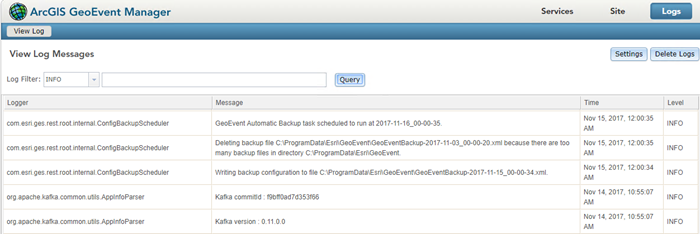
ArcGIS GeoEvent Server has logging capabilities that allow you to monitor the server site. This includes configuring the message logging, filtering and searching the logs, and debugging certain components. Access the GeoEvent Server logs from the Logs tab in ArcGIS GeoEvent Manager.

Filter and search logs
GeoEvent Server allows you to query the available log messages with filter and search capabilities. To filter the log messages, click the Log Filter drop-down menu and choose one of the five message types including Trace, Debug, Info, Warn, and Error. To narrow the query, you can type keywords into the text field to the right of the Log Filter drop-down menu.
GeoEvent Server keeps a selection of the most recent logs in memory and is constantly refreshing its cache. When troubleshooting an issue, you can open the log file in a text editor to perform a full text search. The karaf.log file can be found in the log folder in the installation directory: <ArcGIS Server installation directory>\GeoEvent\data\log.
Debug log messages
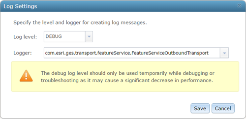
Every component in GeoEvent Server is associated with a specific logger. For example, the com.esri.ges.transport.featureService.FeatureServiceOutboundTransportlogger is associated with the transport, which requests a feature service add or update feature records in a geodatabase's feature class.
To enable debug logging for a component, click Settings from the Logs tab in GeoEvent Manager. From the Log Settings dialog box, set the Log level to Debug and either use the Logger drop-down menu to select the appropriate logger from the list or type the logger's name into the text field.

You can force a refresh of the Logger drop-down selection list by temporarily setting the Log level to Debug and Logger to Root and allowing GeoEvent Server to ingest, process, and disseminate several event records. Ensure that you set the Log level back to Info before proceeding to enable debug logging on a specific logger.
Configure message logging
GeoEvent Server uses the Log4J Logger API for logging messages. Pax Logging supports Log4J with integration for the OSGi framework (GeoEvent Server uses this framework for developing and deploying its Java bundles). The org.ops4j.pax.loggingproject on GitHub implements the OSGi Logging framework.
GeoEvent Server message logging can be configured by editing the org.ops4j.pax.logging.cfg file located beneath <ArcGIS Server installation directory>\GeoEvent\etc.
The maximum size of the karaf.log file at <ArcGIS Server installation directory>\GeoEvent\data\log, the number of rollover files kept, and the format of the logged messages are all configured within the org.ops4j.pax.logging.cfg file.
For example, you can edit the log4j.appender.out.maxFileSize configuration file to update the default (1MB) max file size to allow for larger log files or change the log4j.appender.out.maxBackupIndex file to specify that more message log files be kept when the main log file's maximum size is reached and is rolled to an archive file. These settings can be important if you have high-volume or high-velocity real-time event data that is creating a large amount of log messages.