You can extend the functionality and capacity of the base ArcGIS Enterprise deployment with server roles. Adding server machines on premises or in the cloud to your ArcGIS Enterprise deployment will help you make the most of the ArcGIS Server licensing roles.
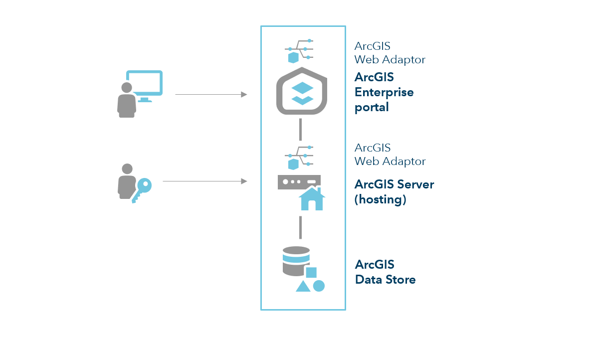
The base deployment of ArcGIS Enterprise comprises the following components:
- Portal for ArcGIS, configured as a portal and licensed for user types, user type extensions, and add-on apps.
- ArcGIS Server, licensed as ArcGIS GIS Server and configured as the hosting server.
- ArcGIS Data Store, configured as a relational and tile cache data store.
- Two instances of ArcGIS Web Adaptor, one configured with the portal and one with the hosting server.
In this configuration, users access your web GIS resources through the portal website. Administrators and publishers can access ArcGIS Server directly for their purposes.
ArcGIS GIS Server
In the base ArcGIS Enterprise deployment, ArcGIS GIS Server acts in two distinct capacities:
- The hosting server that supports the overall Web GIS infrastructure.
- A general purpose GIS Server, where services can be published that reference your own data sources, such as geodatabases.
Many organizations separate these functions into two distinct ArcGIS Server sites to improve the performance of their deployment.
In this configuration, an additional three-machine ArcGIS GIS Server site is federated with your ArcGIS Enterprise portal. This additional site provides dedicated mapping and visualization capabilities to your users. The number of machines in each site will be dictated by your needs for capacity and high availability.
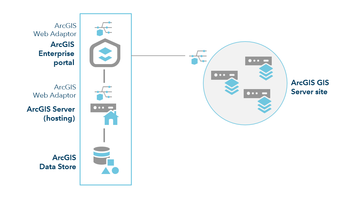
Each machine in the ArcGIS GIS Server site requires a minimum of 8 GB of memory, with more potentially required depending on the number of services published and their usage patterns.
ArcGIS Image Server
ArcGIS Image Server provides two primary capabilities: dynamic image services from mosaic datasets and raster analysis using distributed processing.
If you will only be using dynamic image services, the recommended deployment pattern is to add a dedicated ArcGIS Image Server site to the base ArcGIS Enterprise deployment.
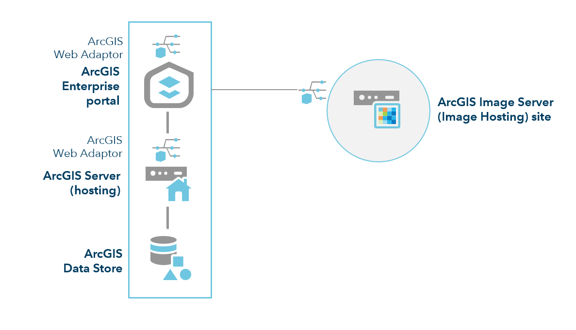
You can also federate additional ArcGIS Image Server sites to this deployment pattern as needed.
For deployments in which raster analysis will regularly be performed on large datasets, to ensure that dynamic image services are not negatively impacted, use separate sites for raster analysis and dynamic image services.
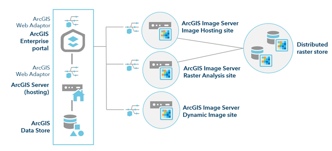
In such a deployment pattern, you must have a minimum of 8 GB of RAM per machine.
See Configure and deploy ArcGIS Enterprise for raster analytics.
Note:
You can only have one ArcGIS Image Server site dedicated to raster analytics in an ArcGIS Enterprise deployment. You can scale the site by adding more RAM or additional machines.ArcGIS GeoAnalytics Server
To federate an ArcGIS GeoAnalytics Server site to your base ArcGIS Enterprise deployment, you must also add an ArcGIS Data Store configured as a spatiotemporal big data store, installed on its own machine:
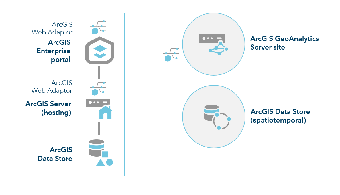
This deployment is appropriate for development and testing, as well as production use when there are no requirements for high availability. To learn about the minimum requirements on your GeoAnalytics Server and spatiotemporal big data store, see Best practices for GeoAnalytics Server sites.
Depending on the size of your data, and the analysis you are completing, you may need to add machines to your spatiotemporal big data store and ArcGIS GeoAnalytics Server site to accelerate your analysis. The diagrams below illustrate this deployment pattern.
Note:
You can have only one GeoAnalytics Server site for an ArcGIS Enterprise deployment. You can scale the site by adding more RAM or additional machines. GeoAnalytics Server supports one-machine and three-machine GeoAnalytics Server site configurations. To learn more about adding machines to your GeoAnalytics Server site, see Add machines to a GeoAnalytics site.The following diagram includes three machines for the spatiotemporal big data store registered with your hosting server and a three-machine GeoAnalytics Server site:
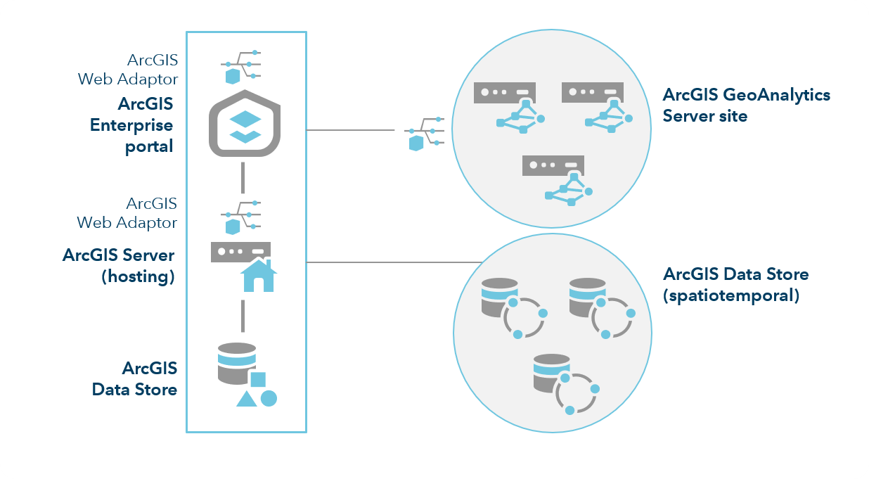
You must also ensure good network throughput from the input data sources configured with GeoAnalytics Server. This includes ensuring good throughput from remote file shares.
Learn more about planning, configuring, and modifying your GeoAnalytics Server site
ArcGIS GeoEvent Server
ArcGIS GeoEvent Server enables real-time, event-based data streams from sensor networks—whether stationary, mobile, or an Internet of Things (IoT)—to be integrated as data sources in your enterprise GIS.
The ideal number and configuration of ArcGIS GeoEvent Server instances for your deployment depends wholly on your data stream or streams—their event velocity and the data size of each event. A single instance of ArcGIS GeoEvent Server can process a stream with a volume of up to 6,000 events per second if the event data size only includes a few data fields and a point. The same hardware and software configuration may only be able to process 2,000 events per second if each event includes several dozen data fields and a many-sided polygon. The type and number of processors incorporated into an event processing workflow will also affect the number of event records you can process each second.
Tip:
Remember, there are only 1,000 milliseconds in a second. If you configure a GeoEvent service with a couple of simple processors (like Field Mapper or Field Calculator) you won't see much of an impact on event processing throughput. More expensive processors, such as Field Enricher, add latency to the event processing workflow. A single Field Enricher can reduce overall even throughput from 2,000 events per second to a dozen or less.
The recommended minimum setup includes a base ArcGIS Enterprise deployment installed and configured on one or more machines, ArcGIS Data Store configured on a second machine, and an ArcGIS GeoEvent Server site deployed on a third.
Note:
Incorporating a three-node spatiotemporal big data store enables high-velocity and large-volume archiving of event data processed by ArcGIS GeoEvent Server. The relational data store type in ArcGIS Data Store can handle data streams with an event volume below 200 events per second.
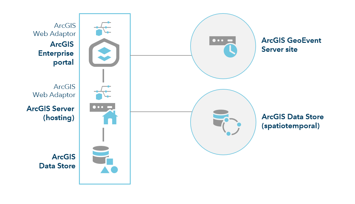
A more minimal set up in which you deploy and license ArcGIS GeoEvent Server on an existing base ArcGIS Enterprise machine is supported. However, system architects should understand the implications of system resource sharing between ArcGIS GIS Server and ArcGIS GeoEvent Server before such a solution is moved into production.
If your real-time sensor network includes multiple data streams, each with a moderate event volume and velocity, configure multiple single-machine ArcGIS GeoEvent Server sites, each dedicated to specific real-time data streams. The diagram below depicts such a configuration, with three independent ArcGIS GeoEvent Server instances, each in their own ArcGIS Server site.
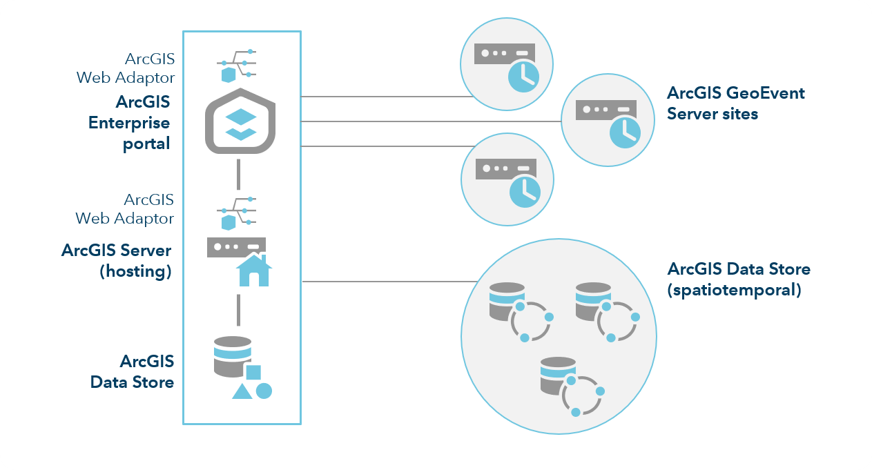
In addition to three independent ArcGIS GeoEvent Server instances, the configuration above illustrates a three-node spatiotemporal big data store registered with your hosting server. The GeoEvent Server and spatiotemporal big data store have been scaled out at the same ratio in this scenario; however, this is not a requirement. For example, your deployment might consist of three instances of GeoEvent Server and a four-node spatiotemporal big data store.
Note:
GeoEvent Server sites are not configured with a web adaptor.
Third-party technologies may be used to support load balancing when distributing sensor data for processing. System administration, however, cannot generally be supported through a load balancer.
Learn more about system requirements for ArcGIS GeoEvent Server.
ArcGIS Notebook Server
ArcGIS Notebook Server is a complete data science platform integrated with the ArcGIS Enterprise portal.
The ArcGIS Notebook Server role enables your ArcGIS Enterprise deployment to host and run ArcGIS Notebooks. Using the Python programming language, you can perform spatial analysis, craft data science and machine learning workflows, manage GIS data and content, and automate ArcGIS Enterprise administrative tasks.
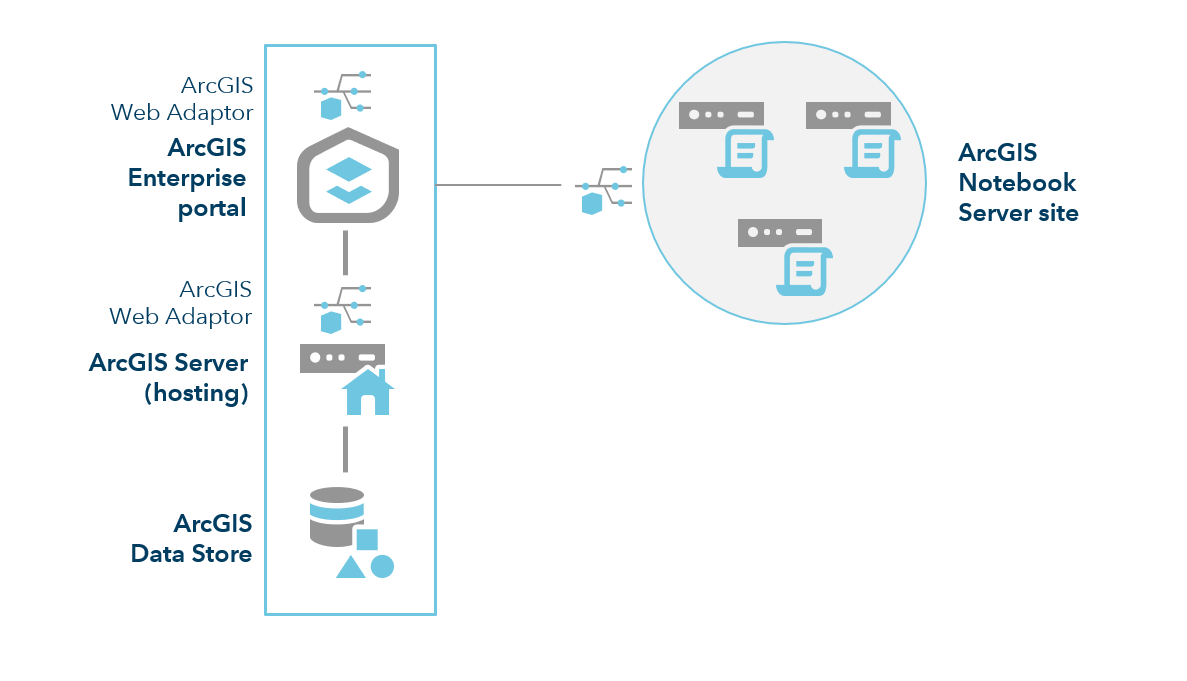
ArcGIS Notebook Server sites are configured and federated with an ArcGIS Enterprise deployment. An instance of ArcGIS Web Adaptor is deployed and configured with each ArcGIS Notebook Server site.
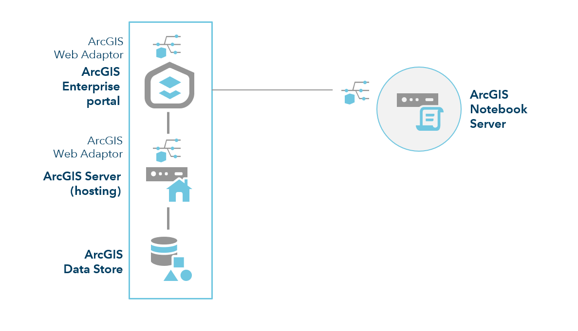
ArcGIS Notebook Server uses containers—virtualized operating systems—to provide each notebook author with their own isolated working environment and computing resources within the machine. To allocate and maintain these containers, ArcGIS Notebook Server works with Docker container software. For ArcGIS Notebook Server to function, Docker Engine must be installed and configured on the same machine. The complete steps to set up Docker Engine are contained in the ArcGIS Notebook Server installation guide.
To accommodate many notebook authors, or to provide each author with a larger containerized workspace, you can join multiple machines to an ArcGIS Notebook Server site.
Note:
At 10.7, only single-machine sites were supported. Multiple-machine sites are supported at 10.7.1 and later.
ArcGIS Workflow Manager Server
ArcGIS Workflow Manager Server is a scalable workflow management system that automates and simplifies many aspects of performing and managing GIS and non-GIS work in your organization. It includes a web app that is integrated with the ArcGIS Enterprise portal and is licensed through the ArcGIS Workflow Manager user type extension.
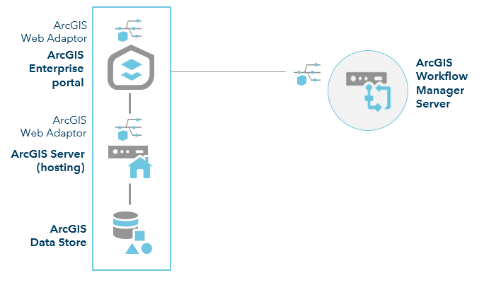
An ArcGIS Workflow Manager Server site is configured and federated with an ArcGIS Enterprise deployment. An instance of ArcGIS Web Adaptor is deployed and configured for the ArcGIS Workflow Manager Server site. ArcGIS Workflow Manager Server can be installed on its own machine or on the same machine as the hosting server.
ArcGIS Knowledge Server
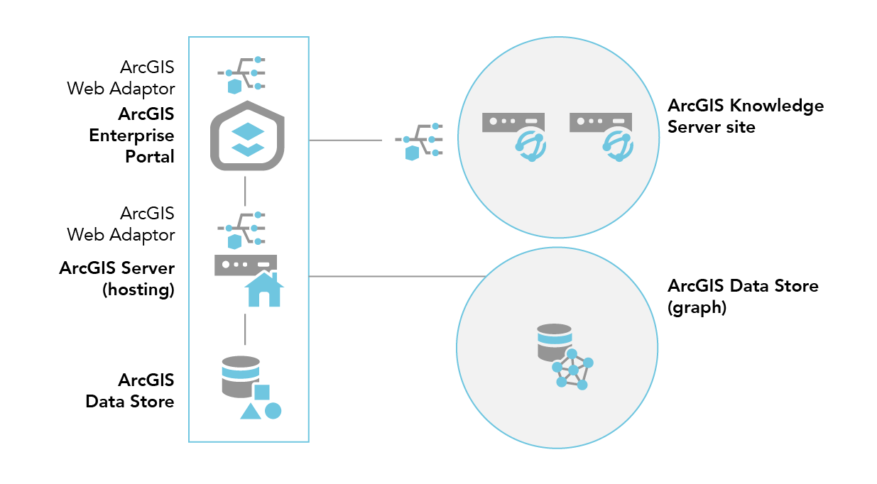
The ArcGIS Knowledge Server role enables ArcGIS Enterprise to model relationships between entities using knowledge graph layers.
To federate an ArcGIS Knowledge Server site to your base ArcGIS Enterprise deployment, you must also add an ArcGIS Data Store configured as a graph data store that is installed on its own machine.
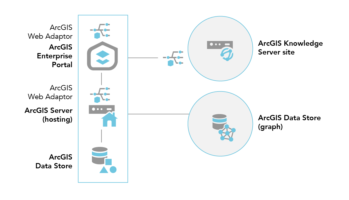
Depending on the complexity and number of analyses you will run on the knowledge graph layer, you may need to add machines to the ArcGIS Knowledge Server site to accelerate your analysis. The diagram below illustrates this deployment pattern and includes a two-machine ArcGIS Knowledge Server site.
